CCL

Climate

Introduction: The Monsoon Phenomenon

The monsoon is characterized by the occurrence of two phenomena: alternating winds and alternating precipitation.

In the northern hemisphere in winter (November to February) a wind blows from the northeast. This wind is generally dry, cool, moderate and pleasant. It generates a cool season, with clear and bright days. For the next three months this wind no longer blows, it is still the dry season but the temperatures rise and the weather becomes stormy. In summer, the wind blows in the opposite direction, from the southwest to the northeast. Passed over the oceans, it is laden with moisture; It brings huge amounts of rain.

The monsoon affects mainland Southeast Asia unevenly (Indochina in the broad sense, located between India and China). The contrast is very strong between the two seasons in the western part exposed to the Indian Ocean (Burma) and weaker in the eastern part (Viet Nam) because the rains have poured further west and conversely the winter monsoon is wetter there because the winds come from the marine northeast.

In the inter-tropical regions, the northeasterly winds (the trade winds of the northern hemisphere) depend on a mechanism based on the existence of two areas of high pressure (i.e. dry) located in the tropics and an area of low pressure (i.e. rainy) located at the equator. Trade winds blow from the tropics towards the equator with a direction altered by the rotation of the earth. In winter, they blow from the northeast to the southwest.

In summer in Asia, the pressure base zone moves very far north, following the apparent movement of the sun and under the effect of the overheating of the continent. It reaches the south of China, the trade winds from the southern hemisphere then enter the northern hemisphere by being deflected to the right. They take a southwest-northeasterly direction at the equator.

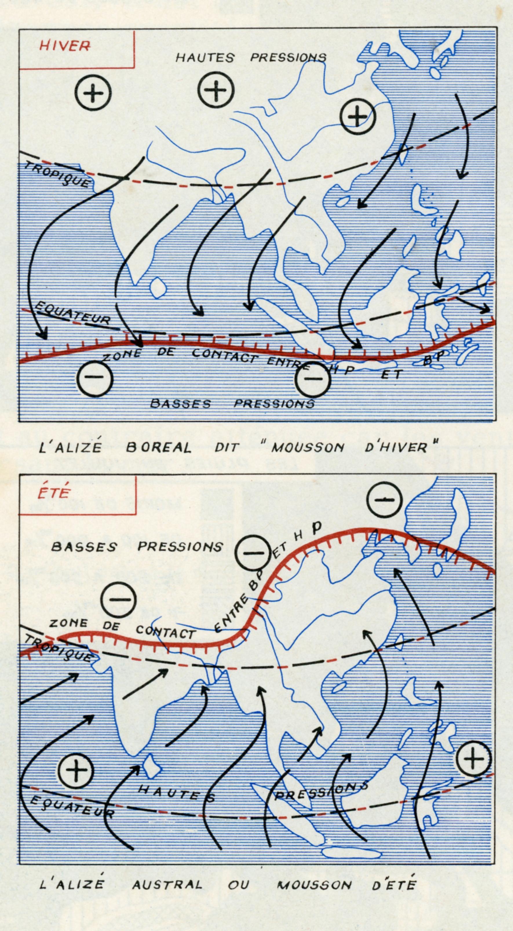
THE CLIMATE OF LAOS: A MONSOON CLIMATE

The monsoon regime gives the Laotian climate its main physiognomy with a dry winter season and a rainy summer season.

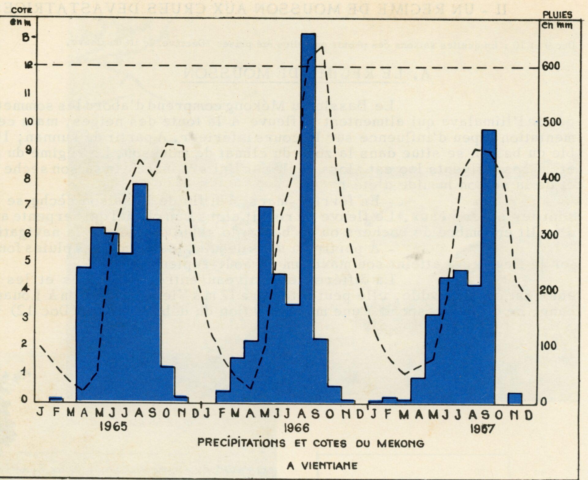
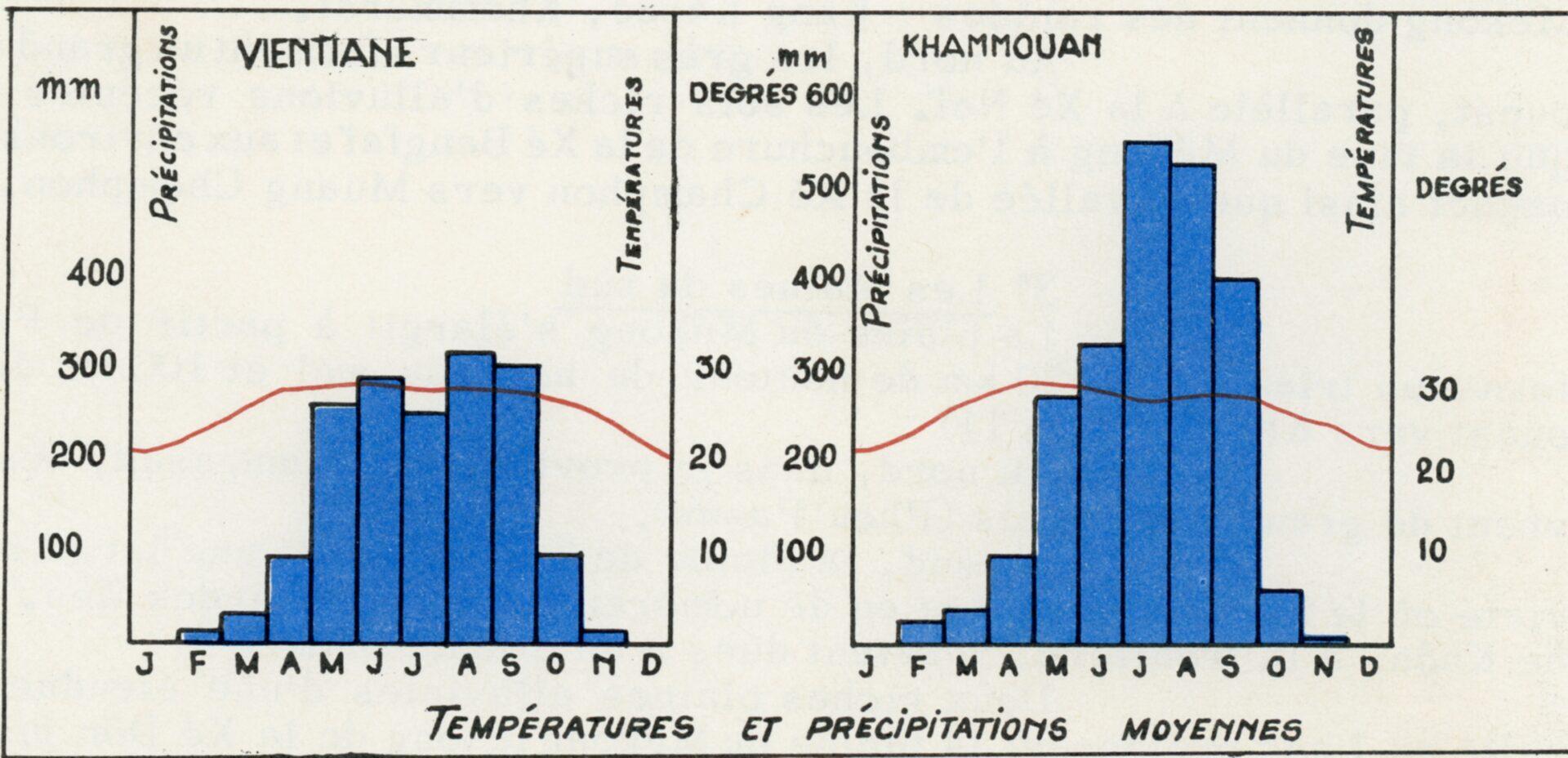
The summer monsoon in Laos coincides with the rainy season. It lasts six months, from mid-April to October. During this period, it is almost daily that the arrival of the beneficial shower is announced by heavy thunder. The south-westerly gales precede the fantastic clouds accumulated in the sky. The water thus precipitated swells the streams and rivers and invades the Mekong, already swollen by the melting of Tibet’s snow. The river covers its beaches, envelops its islands and sees its level rise by ten to thirty meters. It often spills over into the countryside that it fertilizes or devastates. In the city, the damage can be significant. This wet season allows for agricultural work, it is the time of rice fields and weeding.

The dry season begins around mid-October; It coincides with the winter monsoon. Until February the temperatures stabilize between 20° and 25°, the cool and dry wind from the north-east sweeps away the clouds, purifies the sky and brings beautiful and very pleasant weather. From October to December, the rice can grow until it is harvested. The last months of the cycle, March and April, see the temperature peak at almost 40° with an increasing humidity level that makes life quite difficult. This is also the period when rivers reach their lowest levels, usually making them unsuitable for navigation.

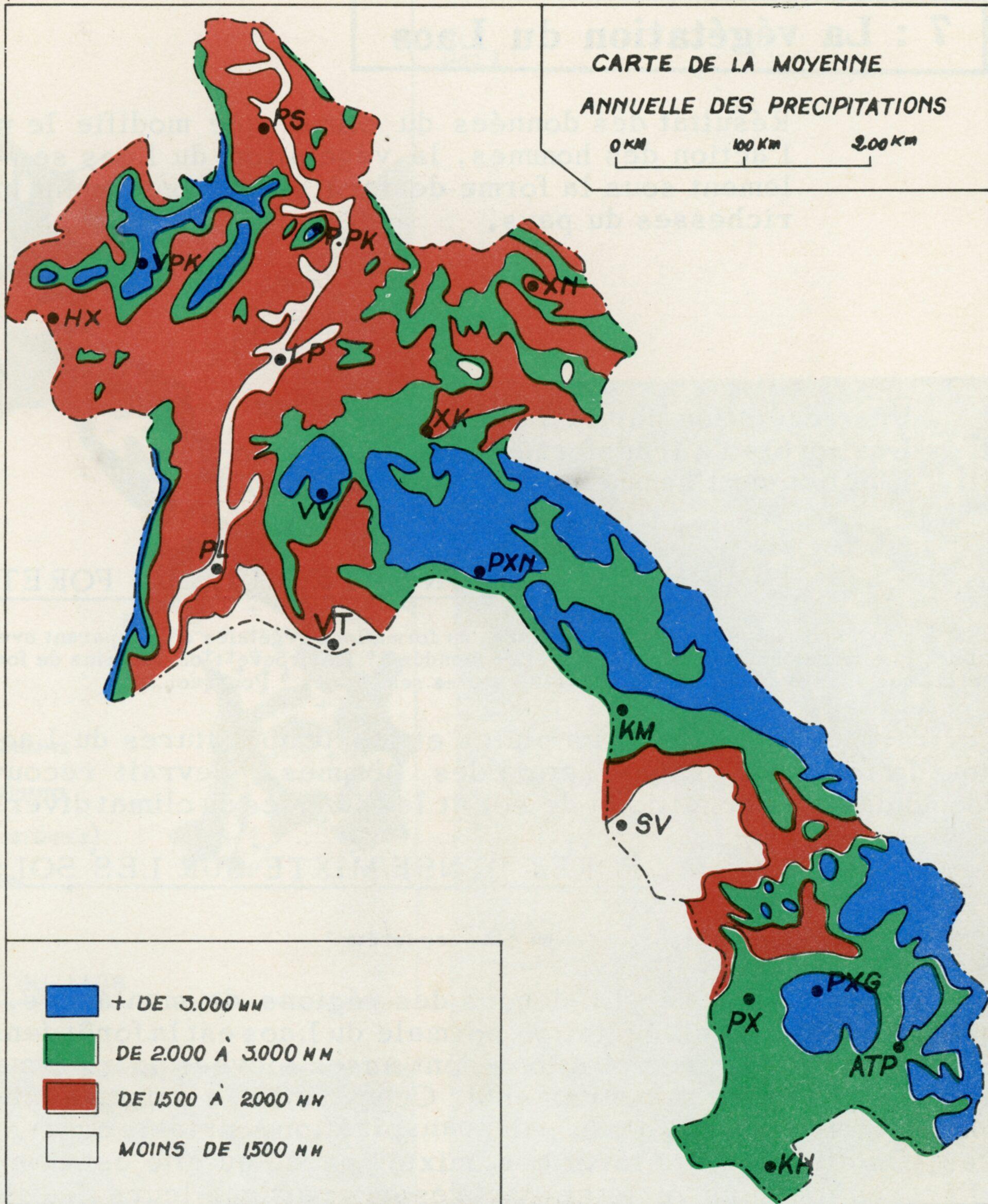
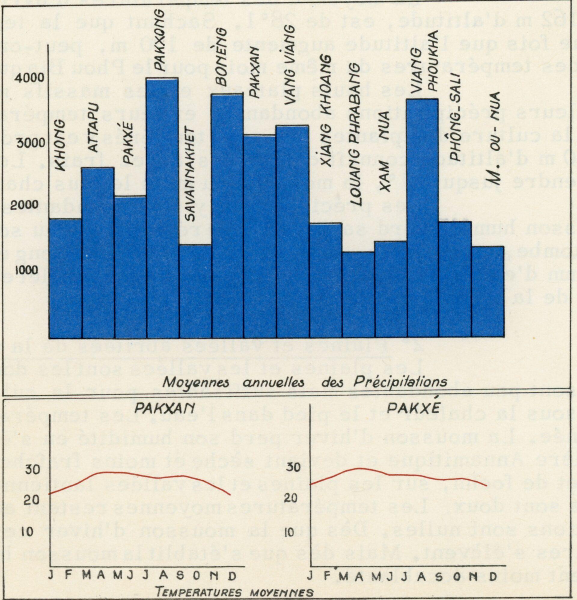
Summer precipitation is abundant but irregular; They are on average more than 1,000 mm per year throughout the country. However, mountain ranges and highlands record more rain than plains and valleys. Similarly, the amount of precipitation varies from year to year; Relative droughts are not uncommon, as are deluges, both of which have a considerable impact on harvests.

TWO REGIONAL SHADES

The map of the country’s climatic domains can easily be modelled on that of the relief. The climate of the plains and valleys is clearly distinct from that of the plateaus and mountain ranges.

At higher altitudes, low temperatures and abundant rainfall are recorded. The average temperature in April in Vientiane, which is located at 162 m above sea level, is 28°1. Knowing that the temperature drops by 0°6 every time the altitude increases by 100 m, we can estimate the average temperature of the same month at the beginning of Phou Bia which culminates at 2820 m. The highlands and mountain ranges are known for their abundant rainfall and low temperatures. This is how the cultivation of plants from temperate countries can flourish there. Xieng Khouang at an altitude of 1150 m experiences quite cool winters. Temperatures can drop as low as 1°C; The average for the hottest month is 23°1. Phongsaly is exposed to a similar situation.

At higher altitudes, the rains are abundant. As it rises, the humid monsoon air loses its ability to hold water in the form of vapor. The rains are torrential. In Pakxong there is an average of 3998 mm of water per year with a very strong peak in July.

The plains and valleys are the areas where rainfall is less abundant but sufficient for the cultivation of rice, a plant that grows in the heat and with its feet in the water. Lowland temperatures are high and humidity is adequate during the growing season. The winter monsoon loses its moisture as it rises to cross the Annamite Cordillera and becomes dry and less cool as it descends under the effect of foehn on the Laotian plains and valleys. Winters are therefore mild, average temperatures remain above 20° and rainfall is zero. As soon as the winter monsoon stops blowing, temperatures rise and agricultural work stops, with the exception of riverside horticulture.

THE IMPACT OF CLIMATE CHANGE

Laos has not been left out of global climate change, quite the contrary. It was ranked 22nd among all countries vulnerable to this change according to the German Watch Climate Risk Index.

Average temperatures are rising, heat waves (temperatures > 35°C) are becoming more frequent, which increases the risk of uncontrolled forest fires during the period from February to June with the air pollution that accompanies them

The rhythm of the rains is affected by delays in the first rains or the occurrence of late rains in November, possibly with mini-droughts in the middle of the rainy season, all of which have an impact on agricultural production, water resources management and rural life.

On the other hand, floods are becoming more frequent, favoured as they are by deforestation, while landslides in steep regions are multiplying

Finally, typhoons from the Gulf of Tonkin now cross the Annamite Cordillera and occasionally devastate southern Laos. These phenomena are accompanied by epidemic and epizootic risks. It is clear that the trend will continue in the coming decades.

THE VEGETATION

NATURAL FOREST VEGETATION

The rains and the temperature of Laos favor the forest everywhere.

DENSE MIXED FOREST ON DEEP SOILS

Outside the mountain regions, when the soil is not too thin, the normal vegetation of the country is dense mixed forest. Temperatures and precipitation are high enough to allow for the growth of a dense forest that is always green. However, the dry season is so long that, to avoid water loss through transpiration, some trees lose their leaves. This forest is called “mixed” because it is made up of a mixture of evergreen and bare trees.

It is also a dense forest (dong) where the very numerous species are distributed according to their height, in four floors. Tall trees grow up to forty meters (may gnang, may bak, may pousy, may bok). These trees have straight trunks; The number of those that lose their leaves depends on the dryness of the place. Underneath grow medium-sized trees of a wider variety of species. These trees have a thinner and less straight trunk, their branches are pointing upwards. Then come saplings and shrubs like mak nam, dok kadom, hang khouang ton used to make torches. Finally, at ground level, there is an abundance of ferns, mosses and mushrooms. These different levels are connected by lianas (khoua) and parasitic plants.

OPEN FOREST ON THIN SOILS

On sandstones or soils that are often hardened, containing a lot of iron and sometimes alumina, called laterites, common in the Savannakhet region, open forest grows. In this forest (khok) the trees have deciduous leaves, they are smaller than in the dense forest and less straight. They belong to a small number of species: may xat, may koung. The forest is said to be open because the trees are far apart from each other, forming a discontinuous canopy. The undergrowth consists of two levels: a level of young trees and bushes of varying density; a continuous carpet of grass, at ground level touched by the sun’s rays. Creepers are rare.

Semi-dense forests make the transition from mixed forest to open forest. It is in these semi-dense forests and where the soil is not too hard that teak (may sak) grows, important for its value. Teak grows naturally around Pak Lay and Houei Say. The May dou, also valuable, also grows in semi-dense forests.

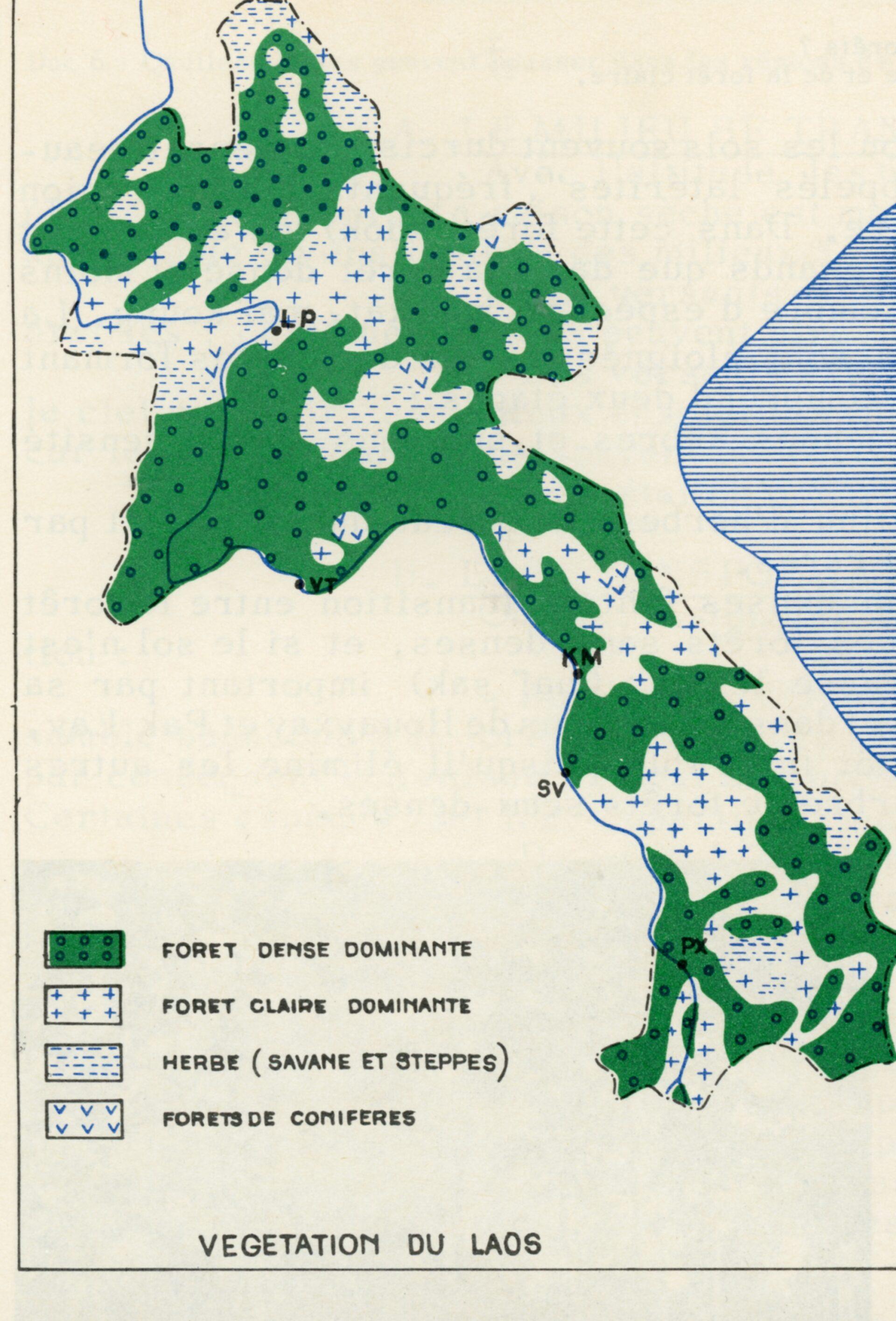
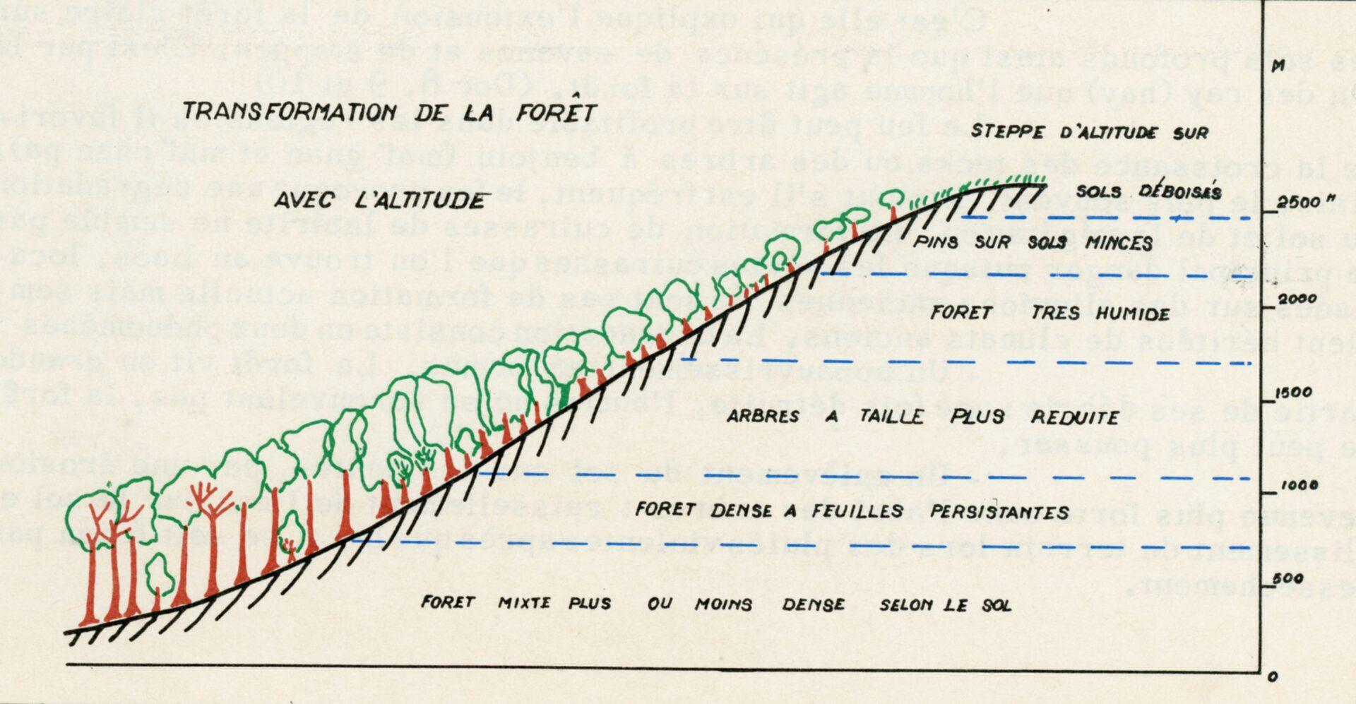
FORESTS CHANGE WITH ALTITUDE

Environments vary and are affected differently depending on the season. In the wet season, with altitude, temperatures decrease while rainfall on exposed slopes increases.  On the other hand, some valleys can be sheltered. East-facing slopes, illuminated to the east when the sky is clear, are better sunny than the illuminated slopes in the afternoon when the sky is cloudy

At the bottom of the slopes from 800 m to 1000 m, the forest closely resembles the dense lowland forest. However, it is wetter and therefore mostly made up of very bushy evergreen trees. Some species make an appearance, may gnang deng and and a may tao tat palm. From 1000 m to 2000 m, the size of the trees decreases with temperature. The most characteristic trees are the may ko kout, the may ko deng, the may ko ket, the may sa chouang, the may mi tho and the may mi nou. The undergrowth includes ferns. Above 2000 m the forest becomes very humid under the influence of clouds and low evaporation. The debris of the forest decomposes slowly, resulting in a soil that is very rich in humus. The trees are not very tall, but they form a dense whole. Always green where mosses and lichens hang from the branches. The most characteristic trees are the may ko khiao, the may kok don and the may som xay.

The open forest of high altitude appears on mixed and poor soils, schist or sandstone. As in the plain, the species are few and the undergrowth is well lit, covered with grass. The originality comes from the species of temperate origin: oaks on fairly deep soils (may sa, may khè) or conifers which constitute homogeneous stands: may pek (pine) or may hing. These trees are best adapted to very poor soil.

HUMAN ACTION MODIFIES VEGETATION

This explains the extension of open forest over deep soils as well as the presence of savannahs and steppes. It is through the burning of rays and the cutting of wood, or even the creation of water reservoirs, that man acts on the forest. If the action is repeated at short intervals, it causes a degradation of the soil and vegetation according to two phenomena: humus depletion and erosion. The forest lives largely on its debris, once destroyed, the humus does not renew itself, the forest can no longer grow. On the other hand, soil removal occurs on the slopes: erosion is no longer slowed down by trees and undergrowth: water runs off and carries away the earth, landslides occur.

The bush succeeds the ray. On an abandoned ray grow tall grasses, bushes and fast-growing shrubs that form a bush. It is a fairly low but very dense vegetation, dominated by a few trees that have resisted fire. Secondary forest follows bush. After a few years, trees replace the bush. They belong to a small number of sun-loving, fast-growing species (may xa kham). Most are not very large and lose their leaves. The undergrowth remains quite dense. It is in the bush and secondary high-altitude forests that benzoin trees (may gnane, may chan pa) grow from which the resin is extracted in the provinces of Xam Neua, Louang phrabang and Saygnaboury.

Grass covers very degraded soils. If fires are repeated, or if the timber is cut too severely, or if the soil is washed away by erosion, only grass can grow. It has the appearance of a savannah or steppe. In the case of the savannah the grass is tall, it can be gna khèm khong or gna kha. The latter covers vast areas in the mountains of northern Laos. A few trees may remain, may ka dom in the lower regions, conifers at higher altitudes. Higher up is the steppe: the destroyed forest cannot be replenished. This is due to the high moisture that dissolves and washes away the rich elements in the soil. The forest gives way to a carpet of low grass.